THREE EAGLES FOUNDATION REMEMBERS FRANK SHADEWALD

Dec 21, 2022 by

THREE EAGLES FOUNDATION REMEMBERS FRANK SHADEWALD

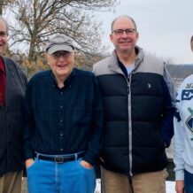
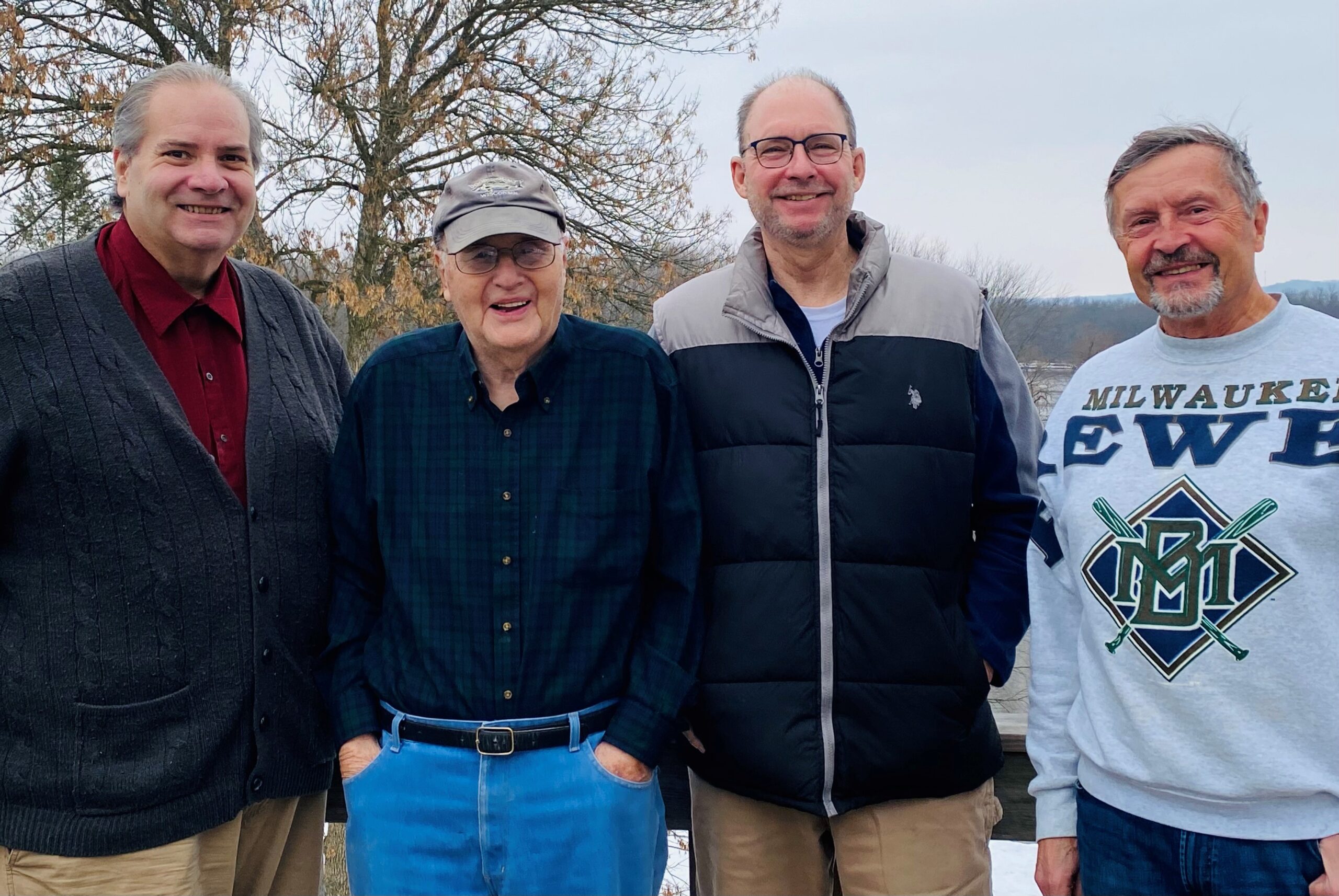
MUSCODA…..Frank Shadewald, founder of the Three Eagles Foundation and former owner of the property known as “Frank’s Hill” in southern Richland County, was remembered by the organization that seeks to continue his vision for the site on the date of what would have been his 90th birthday, December 12th.  The group’s President, David O. Martin, said, “We remember Frank Shadewald on this day for his foresight in establishing the Three Eagles Foundation and donating the land and a modest endowment to enable us to carry forward the work he started to preserve the sacred ground where the effigy mounds and calendar mounds built over one thousand years by Native American people now stand and persevere.” 

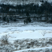
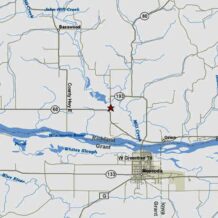
            Shadewald died suddenly in November of 2013.  He purchased the 120 acres near the intersection of STH 60 and STH 193 in the Town of Eagle, Richland County, from the Elder family, a few years after selling his home farm to the Ho-Chunk Nation in 1994.  One reason the Ho-Chunk Nation purchased the Shadewald farm was because the remnants of a large effigy mound group, known as McClary Mound Group #4, contained 16 mounds on the terrace overlooking the Wisconsin River.  The original group included 64 mounds with numerous bird effigies represented. Shadewald became close friends with many members of the Ho-Chunk Nation and traveled extensively throughout the Western Hemisphere, particularly Central and South America, learning about indigenous people and their cultures in the times before European contact.

            Mark Cupp is Vice-President of the foundation.  Cupp said, “The Board of Directors is committed to careful stewardship of the mounds at Frank’s Hill and providing education so that people recognize the significance of the effigy mound building culture and especially the mounds of the Muscoda area.  The tours we provide at solstice and equinox events are one example of our outreach to the public in this regard.”

SHADEWALD REMEMBERED

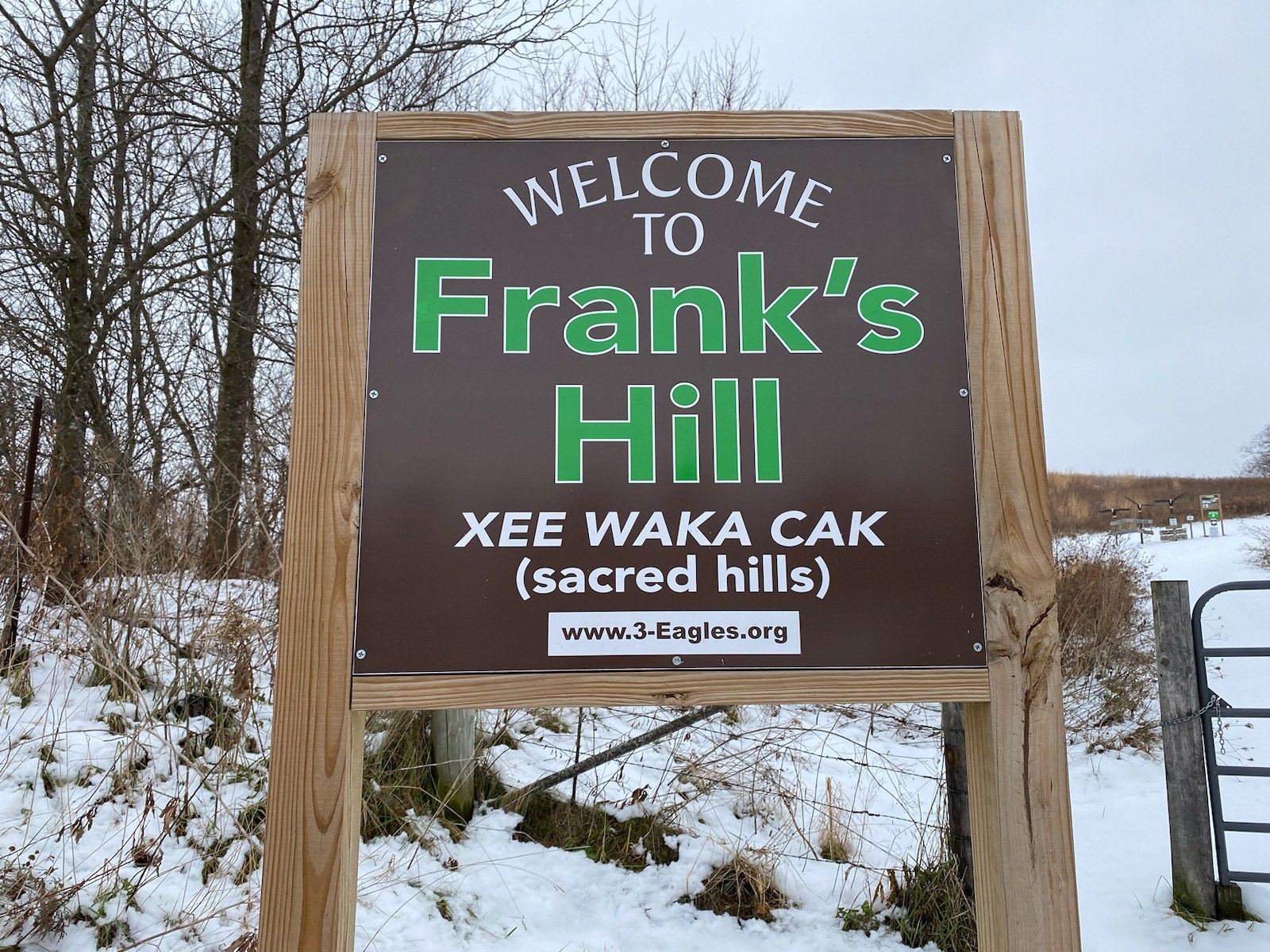
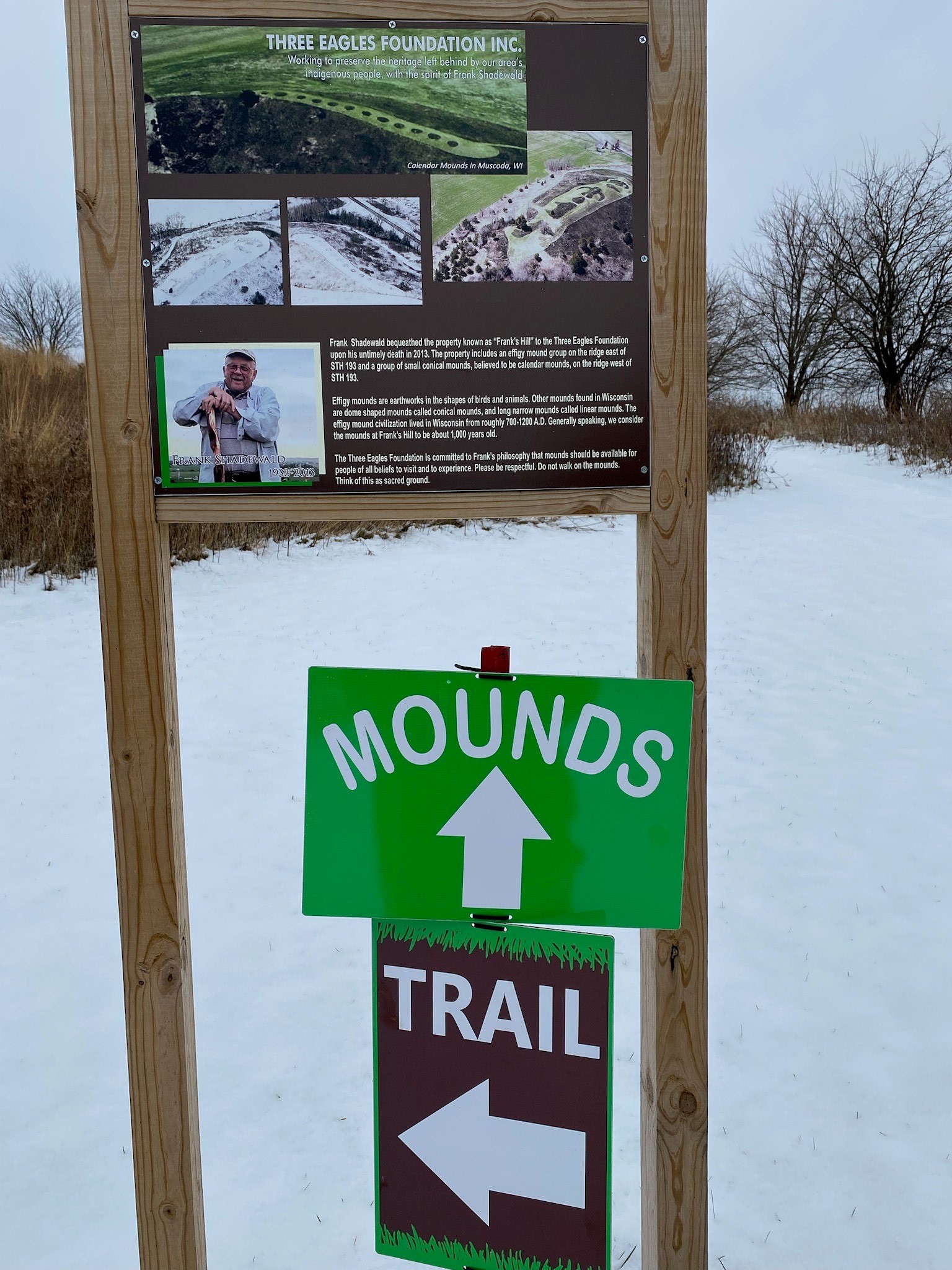
            Recently, the Three Eagles Foundation installed new signage at the property and established a looped walking trail on Hill East, the site of the effigy mound group.  Future plans include additional trail development across the road on the west side of Hwy. 193 where the calendar mounds are located.  The new signage includes directional trail markers and arrows pointing the way to the mound group.  The trail will not be maintained during the winter months but will be open for public use.

            Brian McGraw, the group’s Secretary/Treasurer, leads efforts to restore the native plant community at the site.  McGraw said, “We have been working with our partners to re-establish the native prairie plant community in the uplands at Hill East and Hill West and have more work to do but the results thus far have been encouraging.  The prairie in bloom this year was stunning so we will continue to work on brush removal and control of invasive species as well as new seeding of native prairie plants.”

            Frank’s Hill is open to the public all year except for the gun deer season for safety reasons.  The next public event will be on December 21st in conjunction with the winter solstice.  More information may be found at the Three Eagles Foundation website or Facebook page.

A new sign welcomes visitors to Frank’s Hill, an effigy mound site in southern Richland County, located on STH 193 near the intersection with STH 60 a few miles west of Muscoda.
Frank Shadewald was the founder of the Three Eagles Foundation. Shadewald passed away unexpectedly in 2013 but his vision for the site continues. A sign at the bottom of Hill East describes the mounds and gives background on Frank. The directional signs point the way to the mounds and a new looped nature trail.
The members of the Three Eagles Foundation Board of Directors (left to right): Mark Cupp (Vice President), David Martin (President), Brian McGraw (Secretary/Treasurer), Frank Doerre (Prairie Restoration Specialist/Advisor)
read more

Related Posts

Tags

Share This

WINTER SOLSTICE OBSERVANCE SLATED FOR FRANK’S HILL – Wednesday, December 21st

Dec 15, 2022 by

WINTER SOLSTICE OBSERVANCE SLATED FOR FRANK’S HILL – Wednesday, December 21st

The public is invited to Frank’s Hill in southern Richland County on Wednesday, December 21st, when the setting sun on the shortest of day of the year will be viewed from a small knoll peppered with effigy mounds in southern Richland County.  The property is located on STH 193 just off STH 60 a few miles west of Muscoda and has been the site of many solstice and equinox gatherings in the past.  Weather permitting, area residents are invited to join the festivities and remember events of the past year.  A moment of silence will be observed for those who have passed away since the last trip around the sun.  Following the sunset, attendees are welcome to gather around the campfire to share stories and learn more about Frank’s Hill.  The event is sponsored by the Three Eagles Foundation.

            Frank’s Hill is on the National Register of Historic Places.  A group of unique effigy mounds is situated on the East Ridge where the event will occur, which looks across to the west ridge where a line of small mounds, believed to be calendar mounds, is situated.  The site offers a panoramic vista of the area which once contained the highest concentration of bird effigy mounds found anywhere in the world, including the remnants of the giant Ghost Eagle mound with a wingspan of over ¼ mile.  The Ghost Eagle mound factors into the alignment with the setting sun on the winter solstice.  Most archeologists agree the mounds were built a thousand or more years ago.

            Participants should arrive by 4:00 p.m. to allow for time to hike to the top of the hill.  Dress warmly and bring food, drink, and a chair for sitting around the fire.  Directions to Frank’s Hill are as follows; from the north end of the Muscoda bridge at the intersection of STH 80 & 60, drive west on Hwy. 60 for two miles and turn north on STH 193.  Park by the first gate on the east side of the road, a short distance from Hwy. 60, and walk to the top of the hill.  

            To learn more about the solstice event or for directions, contact Dave Martin at (608) 739-4198 or Mark Cupp at (608) 739-2179.   Additional information may be found at the Three Eagles Foundation website or Facebook page.

read more

Related Posts

Tags

Share This

Lower Wisconsin Riverway Board to Co-Host an Open House on New Riverway Map

Oct 21, 2022 by

Lower Wisconsin Riverway Board to Co-Host an Open House on New Riverway Map

            The Lower Wisconsin State Riverway Board (LWSRB) and Cultural Landscape Legacies, Inc., will co-host an open house for the public to review the draft of a new map showing the cultural and natural history of the lower Wisconsin River valley.  The open house will be held at the Riverway Board office, 202 N. Wisconsin Ave., in Muscoda, from 10:00 to noon, on Saturday, October 29th.

            Christina Dennis, a recent University of Wisconsin – Madison graduate, is creating the map as her senior capstone project.  Her faculty advisor is Dr. William Gartner of the UW-Madison Geology Department.  The new map will be available online for area residents and travelers to download and will point to sites of interest from natural features and public access points to archeological and historical sites in communities from Prairie du Sac to Prairie du Chien.  When completed, limited paper copies of the map also will be available.  Public comment and input are appreciated.  See the map at  https://geography.wisc.edu/lower-wisconsin-riverway-map/

            In addition to reviewing the map, individuals are invited to ask questions about ancient peoples, area effigy mound sites, rock art, early European explorers and Euro-American settlers, local historical sites, and folks may bring artifacts for possible identification.   

            Mark Cupp, Riverway Board Executive Director, said, “Christina Dennis has created a beautiful map with a wealth of useful information about the Riverway.  She is sincere in wanting input from the public to make certain there are no errors so that the final product is accurate and will stand the test of time.  For those who are unable to attend the October 29th open house, please visit the website and offer feedback on the easy to use comment tool.”

read more

Related Posts

Tags

Share This

 FRANK’S HILL OPEN TO PUBLIC FOR EQUINOX EVENT – Thurs., Sept. 22nd

Sep 14, 2022 by

 FRANK’S HILL OPEN TO PUBLIC FOR EQUINOX EVENT – Thurs., Sept. 22nd

FRANK’S HILL OPEN TO PUBLIC FOR EQUINOX EVENT

MUSCODA…..Frank’s Hill, an effigy mound site in southern Richland County, will be open to the public for observance of the autumnal equinox.  Fall officially begins at 8:03 p.m. on Thursday, September 22nd.   Everyone is invited to gather at Frank’s Hill near Muscoda to view the sunset and gather around a campfire on the evening of the September 22nd or to view the sunrise on the morning of September 23rd.  The site also may be visited during the day to see the mounds and the grand vista.  The Three Eagles Foundation will have a tour guide available at 6:30 p.m. on Thursday evening prior to the sunset.  Participants should arrive by 6:00 a.m. to view the sunrise on Friday the 23rd.  The event is subject to suitable weather conditions.  A short hike will be required to the top of the hill that offers a stunning view of the lower Wisconsin River valley. The site is located 2 miles west of Muscoda near the intersection of Hwy. 60 and Hwy. 193. 

            Frank’s Hill is on the National Register of Historic Places.  A group of unique effigy mounds is situated on the east ridge where the observances will occur.  Across Hwy. 193 lies the west ridge where a line of small conical mounds, thought to be calendar mounds, is situated.  The site offers a panoramic vista of the lower Wisconsin River valley.  The lands around the site once contained the highest concentration of bird effigy mounds found anywhere in the world.  The mounds are thought to have been built during the Late Woodland period dating back to one thousand or more years ago.

            To learn more about the equinox event or for directions, contact Dave Martin at (608) 739-4198 or Mark Cupp at (608) 739-2179 or visit the Three Eagles Foundation website or Facebook page.

read more

Related Posts

Tags

Share This

Dec. 21st, 2021 – WINTER SOLSTICE OBSERVANCE SLATED FOR FRANK’S HILL

Dec 15, 2021 by

Dec. 21st, 2021 – WINTER SOLSTICE OBSERVANCE SLATED FOR FRANK’S HILL

The public is invited to Frank’s Hill in southern Richland County on Tuesday, December 21st, when the
setting sun on the shortest of day of the year will be viewed from a small knoll peppered with effigy mounds in southernRichland County. The property is located on STH 193 just off STH 60 a few miles west of Muscoda and has been the site of many solstice and equinox gatherings in the past. Weather permitting, area residents are invited to join the festivities and remember events of the past year. A moment of silence will be observed for those who have passed away since the last trip around the sun. Following the sunset, attendees are welcome to gather around the campfire to share stories and learn more about Frank’s Hill. Physical distancing is encouraged. Face coverings are optional. The event is sponsored by the Three Eagles Foundation.

Frank’s Hill is on the National Register of Historic Places. A group of unique effigy mounds is situated on the East Ridge where the event will occur, which looks across to the west ridge where a line of small mounds, believed to be calendar mounds, is situated. The site offers a panoramic vista of the area which once contained the highest concentration of bird effigy mounds found anywhere in the world, including the remnants of the giant Ghost Eagle mound with a wingspan of over 1⁄4 mile. The Ghost Eagle mound factors into the alignment with the setting sun on the winter solstice. Most archeologists agree the mounds were built a thousand or more years ago.

Participants should arrive by 4:00 p.m. to allow for time to hike to the top of the hill. Dress warmly and bring food, drink, and a chair for sitting around the fire. Directions to Frank’s Hill are as follows; from the north end of the Muscoda bridge at the intersection of STH 80 & 60, drive west on Hwy. 60 for two miles and turn north on STH 193. Park by the first gate on the east side of the road, a short distance from Hwy. 60, and walk to the top of the hill.

To learn more about the solstice event or for directions, contact Dave Martin at (608) 739-4198 or Mark Cupp at
(608) 739-2179. Additional information may be found at the Three Eagles Foundation website or Facebook page.

read more

Related Posts

Tags

Share This